
|
The Welney WebsiteFens, Rivers and the Ouse Washes - an overviewpage created Jan 2006; last updated Monday, 08 November 2021 |
|
|
|
||||||||||||||
|
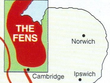
An introduction to the community of Welney, Norfolk'The Fens', the flat low-lying area of East Anglia, used to be a wet, boggy area frequently under water. It was inhabited by sparse populations of fen people who lived on the numerous islands, areas of 'high' ground, who survived mainly by their cunning and local knowledge. Gradually, over several centuries, virtually the whole area has been drained, and today the fens, rivers, defensive banks and washes around Welney (and stretching far beyond) are almost entirely man-made.Geologically, the Fens have two distinct parts. The north is silt land and the south was originally mainly peat (but now with some silt) and often referred to as the 'Black Fens'. Welney is in the latter area which covers much of the former county of The Isle of Ely (now part of Cambridgeshire) and parts of west Norfolk. Todays waterways - variously known as rivers, leams, lodes, drains, eaus, ditches and dykes - need extensive banks to contain them as they are often above the surrounding land. Since most are artificial they are, in the main, straight and are often named after the person who had them dug or financed the work (Morton's Leam, Popham's Eau, Vermuyden's Drain) or by their original width (Forty Foot, Hundred Foot). Some early attempts were made to improve drainage and thereby improve the agricultural value of the fens. The Romans constructed Car from near Cambridge to the north of Peterborough and beyond. This was mainly a canal for transporting food and other supplies from corn growing areas in the south to garrisons in the north but it may also have served as a drain. A stretch of this old canal can be seen on the east side of the A I0 near Waterbeach Barracks. Later, in about 1490, Bishop Morton constructed a waterway from Peterborough to Wisbech to improve drainage in the north part of the black fen. His 'Ieam' which shortened the length of the River Nene, was expected to increase the rate of flow to help to overcome silting troubles which were tending to block the outfall below Wisbech. |
|
||||||||||||
|
However, the most ambitious schemes began in 1630 when Francis Russell, the 4th Earl of Bedford,
formed a 'Company of Adventurers' (venture capitalists) and engaged the Dutch engineer
Cornelius Vermuyden (right) to drain the "Great Level" of the Fens, later
named the Bedford Level. In return for financing the works, the Adventurers received much of the
reclaimed land and according to one source Vermuyden was to receive 95,000 acres for his efforts,
but didn't. Initially Dutch workers were used, but soon
replaced by English. The operation was seen by locals as an attack on their livelihood and there were frequent attacks on the workers
leading eventually to some compensation being given to the fenmen for the loss of fishing and hunting land. |
 Cornelius Vermuyden |
|||||||||||||
|
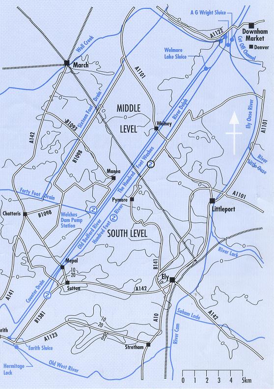
The principal engineering achievement affecting what later became the Ouse Washes was the construction of the Bedford River,
a 21 mile long straight cut from Earith to Salters Lode with a sluice
each end, taking the waters of the Great Ouse more directly towards its
ultimate outflow into the sea. That was completed in 1637 but attracted criticism from other engineers who claimed that the drainage system was inadequate.
In 1638 King Charles intervened and re-engaged Vermuyden to take a fresh look at the problems. In the same year the
complaining commoners appointed Oliver Cromwell of Ely as their advocate against the drainage. However, the Civil War of 1638-1649 (during which 'parliamentary' forces deliberately flooded the region to prevent Royalist advances) put a hold on further works. In 1649 Vermuyden was again hired to drain the Bedford Level. This resulted in the digging of a new tidal channel from Earith, starting a little east (downstream) of the previous cut and running more or less parallel to and mostly approx ¾ mile from it, diverting the normal flow of the Great Ouse to Denver. Completed in 1652 using Scottish prisoners-of-war captured at the Battle of Dunbar, it has two names - the Hundred Foot Drain and New Bedford River; the original Bedford River being renamed 'Old' Bedford River. This second scheme included construction of a sluice at Denver and the Hermitage Sluice at Earith to divert water into the new cut and control levels in the old course of the Great Ouse which meanders between the two via Ely. The greatly diminished flow on the old course from Earith allows it to safely carry water from its downstream eastern tributaries, and Denver Sluice prevents incoming tides to flow up it. The New Bedford River joins, or rejoins, the old course immediately downstream of Denver Sluice. The map and plan on the right should help to explain this, but you may need to read some of the other pages too. Other works at this time were the construction of Welches Dam across the Old Bedford and the cutting of the 40 Foot Drain to join the Old Bedford from the west just north of the Dam. At a later stage, possibly in the 1750s, the River Delph was cut from Welches Dam to Welmore Lake replacing the Old Bedford north of the dam as the eastern edge of the Ouses Washes. The west banks of the Old Bedford/River Delph and the east bank of the New Bedford are higher than their opposite banks so that at times of flood (from both upstream and incoming high tides) water can overflow the lower banks and be held in the area between the rivers. That area became known as the Hundred Foot Washes, and later as the Ouse Washes. Water is retained until the level in the tidal river is low enough to allow it to flow into the New Bedford at Welmore. The Washes still fill with flood water every winter, as Vermuyden intended, although the system is slightly amended. |
 click image for larger viewr /> in new window. 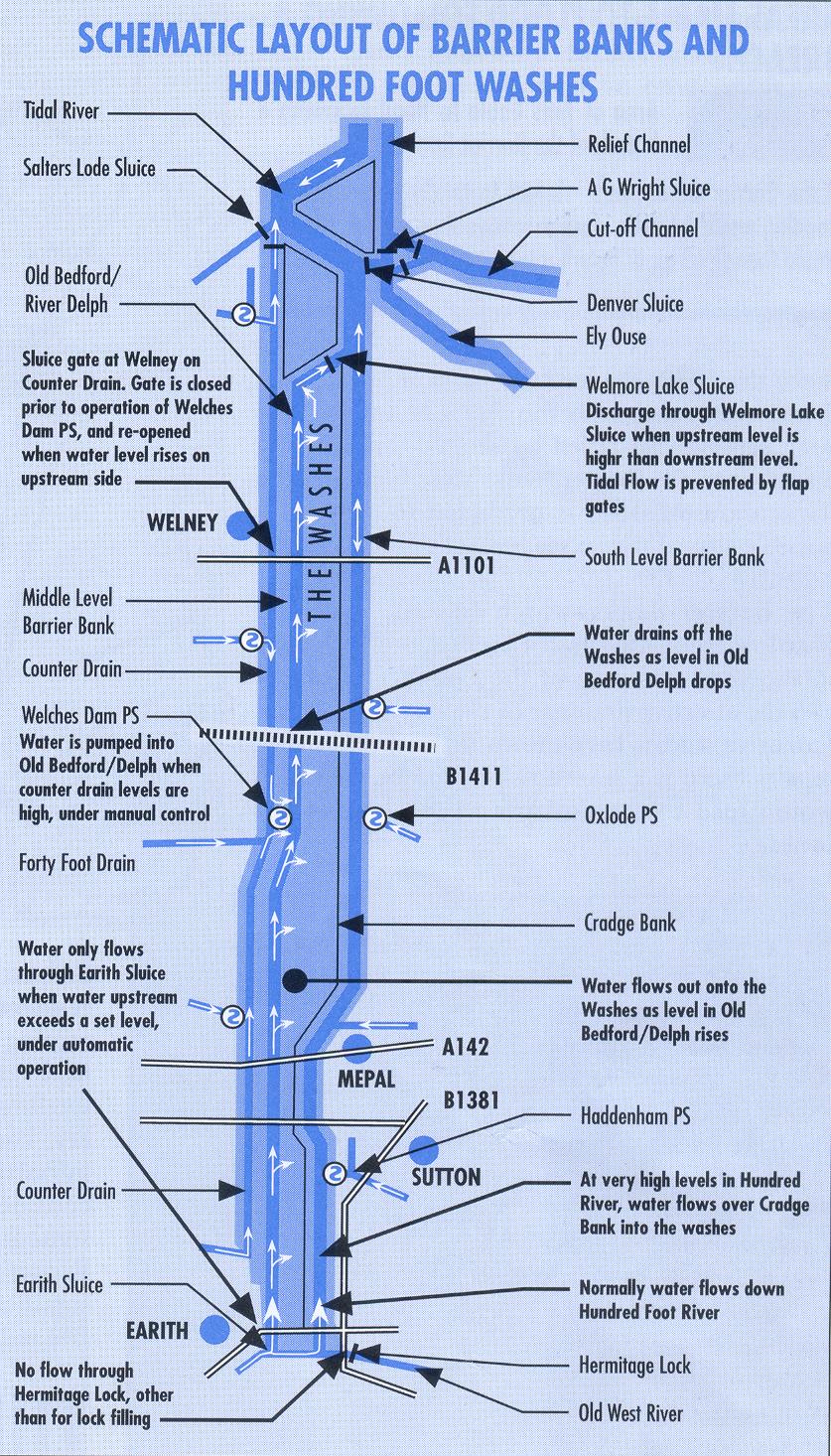 click image for larger view in new window. Another schematic plan, aligned correctly with the compass and including a cross-section of the washes is now available here (large file, will take a while to load Below, the washes in full flood 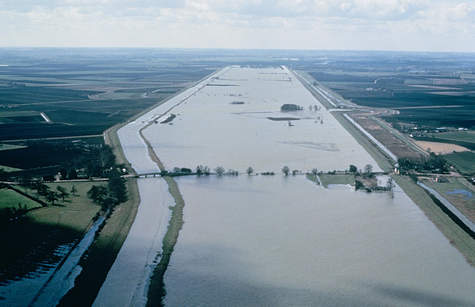
|
|||||||||||||
|
By the start of 17th century the fens were adjudged to be "drained".
However, conditions were far from those we see today. Vermuyden's work
created "summer lands" within the Washes for grazing and enabled arable
farming on the fertile reclaimed land outside the Washes. But despite
the initial success there were unforseen problems. As the peat lands
dried out they shrank until eventually they became lower than the
rivers. By the end of the 17th century much of the reclaimed lands were
once again under water for prolonged periods. |
||||||||||||||
|
That led to the formation of 'Internal Drainage Boards' which undertook
on behalf of the farmers to cut ditches around fields to drain them and
lift the water up into the main rivers with wind-driven scoops or pumps. The links on the right give an introduction to the formation, history and management of this most complex subject; and how the lands are drained. But beware, even the names of the rivers and sluices cause confusion ! Ironically, flood prevention results in part of our parish being deliberately inundated causing the regular and sometimes lengthy closure of a half-mile stretch of the A1101 main road. It is inevitable, a way of life. Many believe the disruption could be reduced by better management and vastly improved warning signs - see the Flooding pages. |
|
||||||||||||
| any comments? please e-mail webmaster | ||||||||||||||